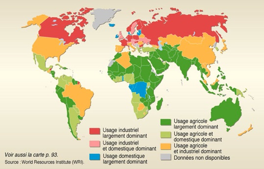
Crisi, oggi

Acqua: non é evidente e poco se ne parla, ma é una delle crisi più gravi, non solo all’orizzonte ma già in corso.
La scarsezza futura (o già attuale) fa sì che i paesi che controllano le sorgenti dei fiumi abbiano iniziato un processo di appropriazione, sia per ragioni energetiche (dighe idroelettriche) sia per irrigazione e consumi diretti. Così i paesi a valle si ritrovano con prospettive spaventose di carenza d’acqua.
Per ora sono soprattutto progetti, e poco é ancora in corso..ma riusciranno a mettersi d’accordo?
E’ il caso dell’Asia, (Nepal, Tibet, India; del Medio Oriente: Turchia, Siria, Irak), ...
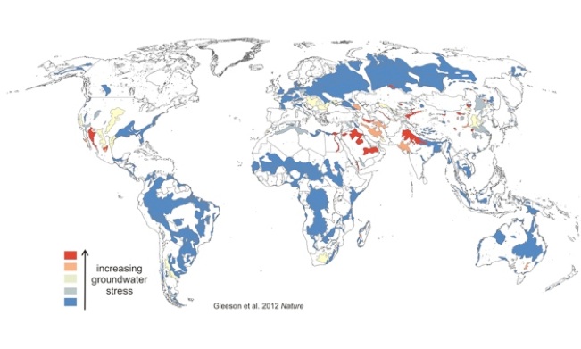
(fonti dei grafici: ‘Le Monde Diplomatique’, ‘Nature’)
sabato 3 novembre 2012
Acqua
1997
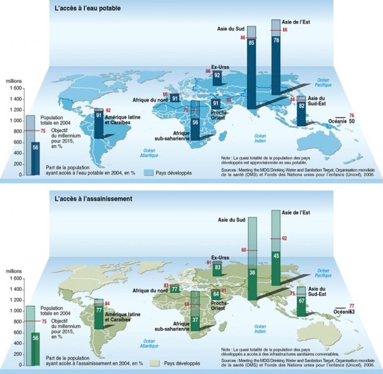
Un essere umano su tre non ha acqua potabile
Battaglia planetaria per l'"oro blu"
Dall'inizio degli anni 70, il mondo ha subito vari "choc" petroliferi. Il prossimo secolo potrebbe conoscere conflitti geopolitci e commerciali ancora più forti, poiché legati al controllo di una risorsa indispensabile alla vita, non sostituibile e, oltretutto, presente in quantità fissa: l'acqua. L'esplosione incontrollata della domanda industriale, agricola, turistica e domestica nei paesi ricchi ha portato all'inquinamento di alcune falde freatiche e ad enormi sprechi che fanno prevedere forti penurie. E' già questa la situazione per più di 1,4 miliardi di esseri umani, privi di acqua potabile. Chi sarà l'arbitro tra i bisogni dell'insieme degli abitanti della terra e l'interesse dei privati? Non potrà essere il mercato, acceleratore di ineguaglianze, a sostenere questo ruolo. Ormai è urgente arrivare a un altro approccio cooperativo e internazionale della gestione di ciò che deve restare, o tornare ad essere, un bene comune dell'umanità.
Di Mohamed Larbi Bouguerra * ‘Le Monde Diplomatique’
__________________________________________________________________________________________________
NATURE CLIMATE CHANGE | PERSPECTIVE
Global insights into water resources, climate change and governance
-
•R. Quentin Grafton, Jamie Pittock, Richard Davis, John Williams, Guobin Fu, Michele Warburton, Bradley Udall, Ronnie McKenzie, Xiubo Yu, Nhu Che, Daniel Connell, Qiang Jiang, Tom Kompas, Amanda Lynch, Richard Norris, Hugh Possingham & John Quiggin
-
•Affiliations
-
•Contributions
-
•Corresponding author
Nature Climate Change (2012) (2012) doi:10.1038/nclimate1746
Received 18 January 2012 Accepted 15 October 2012 Published online 25 November 2012
-
•
Abstract
-
•Abstract Main Trends in river flows and precipitation Climate change and water extractions Water governance insights References Acknowledgements Author information
The threats of climate change and the trade-offs between extractions and flows are examined for the Colorado, the Murray, the Orange and the Yellow Rivers. In all four basins, and over a long period of time, outflows have greatly reduced as a direct result of increased water extractions. Although climate change will aggravate hydrological impacts on river systems, currently high levels of water extractions remain the principal contributor to reduced system flows. Changes in governance, including sharing the variability between the environment and consumers, are urgently required if the health of these rivers is to be maintained.
At a glance
-
•Figures
left
-
1.
-
2.
-
3.

-
4.
-
5.
-
6.
-
7.
-
8.
-
9.
-
10.
right
Main
-
•Abstract Main Trends in river flows and precipitation Climate change and water extractions Water governance insights References Acknowledgements Author information
In past decades there has been a sharp decline in per capita water availability in many countries1, and this is expected to get worse with growing populations and economic growth2, 3. If per capita water availability continues to fall, it will exacerbate underlying tensions between extractive and in-stream uses of fresh water and, with business as usual, will result in further environmental decline4.
Research so far has focused either on the microscale, with studies of particular rivers, or on the macro- or global scale, with studies of anthropogenic stresses on river systems5, 6, climate change impacts7, 8, 9 or climate adaptation10, 11. Despite this rich literature, a mesoscale analysis remains unexplored, especially cross-continental, basin-scale comparisons.
We compare both the effects of water extractions and projected climate change on river flows for four continental river systems. We show that the hydrological effects of past and current water extractions far exceed projected impacts of climate change. This is an important realization, but paradoxically offers the promise that improved water governance could both reduce existing water stresses and prevent further deterioration as a result of projected declines in inflows due to climate change.
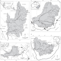
The analysis focuses on rivers in semi-arid zones with 'closed' drainage basins6 that lie in the 30–40° latitude range in which projected drying associated with climate change is most pronounced12. The four river systems are: the Colorado, the Murray–Darling, the Orange–Senqu and the Yellow (Huang He) (Fig. 1; Table 1). Our contribution is: (1) to demonstrate the hydrological effects of current management practices on these rivers; (2) to summarize the findings of previous studies of hydrological ecosystem impacts on these river systems; (3) to compare current water extractions with the projected hydrological consequences of climate change; and (4) to present insights from these river systems into water governance to improve ecosystem health in the presence of climate change.
Figure 1: Location of the four river basins.
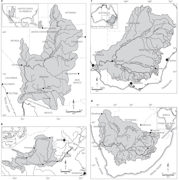
a, Colorado; b, Yellow; c, Murray–Darling; d, Orange–Senqu. Maps drawn by Clive Hilliker, Australian National University.
Table 1: Rivers considered in this research and climate change projections for the Colorado, Yellow, Murray–Darling and Orange–Senqu basins.
Trends in river flows and precipitation
-
•Abstract Main Trends in river flows and precipitation Climate change and water extractions Water governance insights References Acknowledgements Author information
Figure 2a shows that the outflows of the Colorado River at the US–Mexican border are a tiny fraction of the upstream inflows measured at Lees Ferry. Although evaporation accounts for some of this difference, most of it is a result of water extractions from the river. Similarly, Figs 3a to 5a show that there is a very large disparity between simulated and actual flows in the Yellow, Murray and Orange rivers. This difference is primarily a result of water extractions and associated infrastructure. In particular we examined the median outflows for the most recent 5 years for which data were available and compared these with the median simulated (natural) flow (see Figs 2a, 3a, 4a and 5a; inflows at Lees Ferry used in the case of the Colorado). Our calculations show that over the most recent 5 years, current median outflows are 0%, 41%, 12% and 33% of their current median simulated (natural) flows for the Colorado, Yellow, Murray and Orange rivers.
Figure 2: Colorado River.
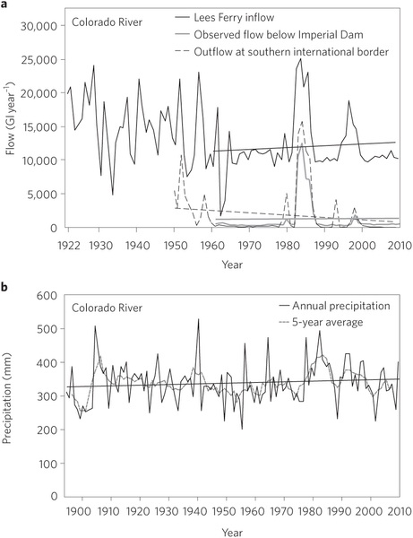
a, Observed inflows at Lees Ferry and outflows below Imperial Dam and at international border, in gigalitres (Gl) per year. Data at Lees Ferry are taken as 'natural' inflow for the lower Colorado although there are diversions upstream (and because more reliable natural flow modelling is not available), and observed flow at the southern international border as the river outflow. Trend lines for inflow, observed flow and outflow are shown. Source: US Geological Survey, available at http://waterdata.usgs.gov/nwis. b, Annual precipitation, 5-year precipitation average and trend in the Colorado River basin. Source: WestMap Climate Analysis & Mapping Toolbox, available at http://www.cefa.dri.edu/Westmap/westmappass.php.
-
•Previous
-
•Next
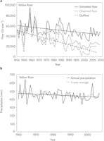
Figure 3: Yellow River.

a, Simulated flows and observed flows at Hua Yuan Kou, and observed outflows at the last gauging station, Li-Jin. Trend lines for simulated flow and outflow are shown. Source: Yellow River Commission. b, Annual precipitation, 5-year precipitation average and trend in the Yellow basin. Source: National Meteorological Administration of China18. Official data series for observed and modelled flows undertaken by the Yellow River Commission. The difference between observed runoff and modelled runoff is due to: (1) the amount of surface water diverted, less return flows; (2) water losses from evaporation and seepage during storage; and (3) interbasin transfers18.
-
•Previous
-
•Next
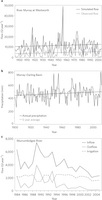
Figure 4: River Murray.
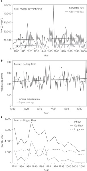
a, Simulated natural flows and observed flows on the River Murray at Wentworth. Trend lines for simulated flow and outflow are shown. These flows were derived by the Commonwealth Scientific and Industrial Research Organisation (CSIRO), drawing on gauge data and linking climatic and hydrological models29. b, Annual precipitation, 5-year precipitation average and trend in the Murray–Darling Basin. Source: Bureau of Meteorology, available via http://go.nature.com/A54yaZ. c, Murrumbidgee River: observed inflows from the river and major tributaries above Wagga Wagga, water extraction for irrigation and outflow at Balranald24
-
•Previous
-
•Next
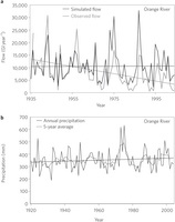
Figure 5: Orange–Senqu River.
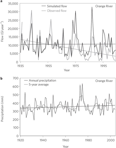
a, Simulated natural flows and observed flows at Vioolsdrift Weir on the lower Orange River49. Trend lines for simulated flow and observed flow are shown. b, Annual precipitation, 5-year precipitation average and trend in the Orange–Senqu River basin50.
-
•Previous
Figures 2b–5b show the annual precipitation and 5-year average for each of the rivers. The time period ranges from 50 years for the Yellow River to 90 years for the Orange and about a century for the Colorado and Murray Rivers. In all four river systems there are very large temporal annual variations in precipitation. Although there are extended periods of low precipitation in all of these basins, there is no apparent downward long-run trend in precipitation with the possible exception of the Yellow River. Our assessment of these long-run flow and precipitation records is that the marked decline in outflows in these rivers is largely a result of increased water extractions.
Colorado The Colorado River is primarily a snow-melt driven river with 92% of the flow originating above the Grand Canyon of the Colorado. Since the 1930s, significant infrastructure has been constructed on the system, including the two largest reservoirs in the United States (Lake Mead and Lake Powell) such that total storage in the basin now exceeds four times the annual flow. Flows in the Colorado were allocated in perpetuity by an interstate compact in 1922 between the Lower Basin states (California, Arizona, Nevada) and the Upper Basin states (Colorado, Utah, Wyoming, New Mexico) with roughly half going to each basin segment13, 14. By treaty the United States is obliged to supply 1.845 km3 per year to Mexico (9.1% of average flows13), which diverts any remaining flow of the river for irrigation at the Morelos Dam close to the Mexico–California border. No flows have reached the sea since the late 1990s, degrading the once ecologically rich delta that is designated a Wetland of International Importance under the Ramsar Convention15, 16.
The current drought in the Colorado Basin shows that the environment incurs a much bigger reduction in its water volumes during times of low inflows than do all consumptive water users in the Basin (Fig. 2a). The loss of flow has reduced the delta to about 5% of its original area. Freshwater-dependent native cottonwood and willow forests which support relatively high biodiversity have been replaced by salt-tolerant, non-native salt cedar and iodine bush which support lower biodiversity. In 2010 the United States Bureau of Reclamation acknowledged, for the first time, that water diversions exceed supplies and began a 2-year study to investigate future management options17.
Yellow The observed stream flow of the Yellow River has decreased substantially over the past 50 years coincident with population growth and regional economic development. Its stream flow shows a variability that is relatively lower in El Niño months and higher during the La Niña period18.
The irrigated area sourced from the Yellow has increased enormously from some 0.8 million hectares before 1949 to 7.51 million hectares in 1997. Since the completion of a large-scale irrigation project in 1969, the frequency of zero flow in sections of the river has increased. These events have started earlier in the year, and their duration has lengthened such that during 1997 no water discharged to the sea for 330 days. Increased water extractions for irrigation have resulted in a 35% decline in flows19, 20.
The adoption of more environment-friendly practices in the operation of the Xiaolangdi Reservoir since July 2002 and the reallocation of some agricultural water to the environment has restored a degree of runoff and sediment discharge into the Yellow delta21. This has revived ecosystem services including water supply, fish, tourism and biodiversity conservation21, 22, 23. Ecosystem structure and functions seem to have improved in over 50 km2 of wetlands and now provide more favourable habitats than previously for a variety of migrating and breeding birds, including some rare species22. Despite the recent increases in outflows, they remain well below natural flows from 50 years ago (see Fig. 3a).
Murray–Darling The Murray–Darling river system has a very high variability in annual flow characterized by sequences of decade-long droughts and periodic large floods (Fig. 4a)24. The system has low runoff coefficients and experiences high natural in-stream losses such that its flows are small compared with other similar-sized basins. Over 80% of the basin's surface area is used for agriculture: 2% of that is irrigated25, 26. Irrigation uses, including conveyance losses, account for about 90% of the total fresh water diverted in the basin. Current water extractions are such that floodplains have become much drier and the connectivity between floodplains and rivers has been greatly reduced27, 28. In addition, the frequency of zero-flow years at the mouth of the Murray River, a Ramsar site, has increased from about 1% prior to European settlement to over 40% in recent years29, 30.
During the 2002–2010 Millennium drought (Fig. 4a), environmental flows across the Murray–Darling Basin declined by a factor of four compared to the decline in water extracted for irrigation25, 29 despite an overall cap on extractions that varies according to inflows and storage levels. The proportion of flows diverted for agriculture in the River Murray increased from less than 50% in the 1980s and 1990s to 76% over the period 2000–2008 (Fig. 4a). Outflows from the second largest tributary to the Murray, the Murrumbidgee River, declined to near zero while the water extraction for irrigation declined by less than 25% (Fig. 4c)31.
As a consequence of the disproportionate impact on environmental flows, lakes and river channels turned acidic in some parts of the basin, salinity levels in a part of the Coorong (an attached coastal lagoon) rose to five times the level in the sea, and invertebrate, fish and water-bird diversities declined sharply. Some climate modelling scenarios project that, by 2030, these zero- or low-flow events at the Murray Mouth may be expected 69% of the time under current water consumption patterns29, 30.
Orange–Senqu The Orange–Senqu River basin is characterized by highly variable hydroclimatic conditions, with strong aridity in the western parts of the basin, marked rainfall seasonality and, in many areas, a relatively short rainfall season32. The river's natural flow has been substantially reduced by extensive water use for domestic, industrial and agricultural purposes. The river has been highly developed for water extractions and storage that includes 31 major dams as well as numerous large inter- and intrabasin transfer schemes. Irrigation consumption accounts for about one-third of the total runoff whereas evaporation from storages plus growth of riparian vegetation appropriates less than 20% of the total runoff33. The ecologically significant Orange River mouth is a Ramsar site that was listed on the Montreux Record of sites undergoing detrimental changes in ecological character due, in part, to declining environmental flows34.
The Orange–Senqu has acute water-quality challenges that are a result of industrial and agricultural activities depleting flows35. Poor water quality imposes direct human costs on downstream users due to increased water purification costs, decreased agricultural productivity and loss of water for dilution purposes. These costs are especially high for poor communities that lack adequate water treatments and alternative water sources, and also have a deleterious impact on riverine habitats and ecosystem health.
Climate change and water extractions
-
•Abstract Main Trends in river flows and precipitation Climate change and water extractions Water governance insights References Acknowledgements Author information
A key concern with all four rivers is that the detrimental impacts of existing water use regimes will be exacerbated under climate change. Table 1 summarizes various studies for these four rivers. It indicates that, at least for these mid-latitude basins, climate models suggest that climate change will raise temperatures (and possibly evaporation) that can result in reduced flows.
The projected reductions in flows, for different time periods, range from 4 to 18% for the Colorado, between 9 and 29% for the Yellow and up to 69% for the Murray–Darling. In the case of the Murray–Darling and Orange–Senqu there are also scenarios where water availability increases. If the climate change projections prove correct, it would seem that the greatest threat to river ecosystem health in these basins will continue to be the high levels of water extractions. This conclusion does not imply that climate change is not a threat, nor does it suggest that other climate adaptation policies should not be adopted in the river basins, but it does support the view that the most effective adaptation option is to reduce consumptive water uses.
The four river basins provide insights about the shortcomings of current water governance in the face of reduced water availability under climate change. Capturing a large proportion of the inflows for consumptive purposes imposes large costs through reduced riverine ecosystem functions in all four rivers. This diminishes opportunities to capture ecosystem services for agriculture, fisheries, forestry and tourism. In some rivers, such as the Yellow, water extraction has increased sedimentation and the risk of flooding in the lower reaches, which is one reason that the Chinese Government has reallocated water to environmental flows. Although only documented for the Murray–Darling Basin, improved ecosystem services associated with increased flows—arising from floodplain vegetation, waterbird breeding, native fish and the rehabilitation of the Coorong, Lower Lakes and Murray Mouth—are comparable to the value of irrigated agriculture36, 37. The proposed allocation of water for environmental flows in the Murray–Darling Basin is based on the premise that these flows sustain biodiversity and ecosystem services. In addition, over-extraction reduces the reliability of surface and groundwater supply as flood plain flooding can be critical in many rivers systems for groundwater recharge29.
The high temporal and spatial variability of river inflows in all four rivers requires practices that protect the environment during periods of low flows. This demands water allocation management plans that 'share' the variability equally between users and the environment. Current practices that give higher priority to consumptive water diversions at the expense of environmental flows38, 39, especially when aquatic ecosystems have become vulnerable because of long-term below-average inflows, will need to change to allow rivers and their habitats to adapt, where possible, to climate change.
Water governance insights
-
•Abstract Main Trends in river flows and precipitation Climate change and water extractions Water governance insights References Acknowledgements Author information
Each of the river basins provides specific lessons about water governance that may be applicable more generally. Both the Yellow and the Murray–Darling show that reallocations from water diversions to environmental flows are feasible and, at present, seem to have been achieved with only minimal cost to the existing water users23, 40. In the case of the Yellow, the water-use reductions have been imposed administratively by the central government, which may not be possible in countries with different political economies. By contrast, in the Murray–Darling Basin increased environmental flows have primarily occurred through the voluntary sales of water rights by irrigators to state and federal governments supported by a robust legal and institutional foundation41.
Australia and China show that remedial activities can occur under different governance structures. In the case of the Yellow River the processes have been 'top down' with strong central government direction. Although in Australia it is also true that centralisation of basin management has occurred as a result of the 2007 Water Act42, the reallocation of water to the environment has arisen because of a series of rolling reverse tenders of water rights. By contrast, the Colorado and Orange–Senqu are governed by multiple jurisdictions that coordinate their actions in less centralized ways. This may explain why, so far, there has been little action to reallocate water to the environment in these two rivers despite basin-wide institutions (the Colorado River Compact and Orange–Senqu River Commission, respectively).
The Yellow and the Murray–Darling show the potential benefits of nested institutions for basin planning where single basin authorities plan or manage water flows across state/provincial boundaries. Nevertheless, in both cases a reallocation of water for environmental purposes was precipitated by a crisis that led to a sharp decline in flow at the river mouth. In South Africa, the overthrow of the inequities of the apartheid era provided the opportunity to introduce water reforms including the recognition of environmental water requirements. In the case of Australia, the appetite for water reform to resolve common problems has noticeably diminished following the end of the Millennium Drought in 2010. A failure to implement reforms fully in both South Africa and Australia, and also in the Colorado, is attributable to stakeholders who have the most to lose from a reallocation of water to the environment and whose views dominate in the absence of a crisis43.
As is the case with climate change mitigation whereby carbon trading can reduce the overall cost of reducing greenhouse gas emissions, water markets may also encourage the reallocation of water from consumptive to in-stream uses by lowering the economic costs of such transfers. The Colorado, Murray–Darling and Orange–Senqu all allow trading in water rights. In the case of the Orange–Senqu the trade is highly restricted and localized. On the Colorado interstate and international rules have, heretofore, restricted trade between states, and within states the seniority system confers different values on each water right that complicate and limit trade44. By contrast, in the southern part of the Murray–Darling there is a well-developed and very active water market38, 39.
Water markets allow water to be reallocated to higher-value uses. By providing a price signal to water users due to the reallocation of water to the environment or reduced inflows, a water market encourages water-saving practices38. In the case of the Murray–Darling these practices, coupled with the trade and transfer of water to higher-value consumptive uses, allowed the gross value of irrigated agricultural production to remain virtually unchanged during the Millennium Drought despite a fall in extractions of about 70% from 2000–01 to 2007–08 (refs 25,40). Water markets have also allowed the Australian federal government to purchase water rights from willing irrigators and, thereby, generate public benefits from increased river flows without penalizing existing water users. Although the direct government purchase of water rights at market prices may not be possible in less affluent countries, non-governmental and multilateral aid and development agencies could assist by either leasing or buying such rights or otherwise aid reallocation in the absence of such rights.
A lesson from the Orange–Senqu and the Murray–Darling is the need to match legislative goals with on-ground water management. This is consistent with a recent study of 17 countries by the Organisation for Economic Co-operation and Development (OECD) that concludes water crises are principally crises in governance characterized by a mismatch of the geographical boundaries in terms of the hydrology and administrative responsibilities and inadequate funding, conflicting goals, and poor accountability45. Thus, although South Africa's 1998 Water Act is widely viewed as one of the most progressive in the world with its provisions for ecological reserves, a lack of resources and capacity has impeded its implementation at the catchment level46, 47, 48. Despite the need for better management, the 2007 Water Act for the Murray–Darling, which accords a priority to environmental sustainability, will not begin until 2019 and not be fully implemented until 2024. This is assuming the Basin Plan passes in Australia's federal parliament; as of October 2012, this is in doubt because of opposition by some states and interested parties.
This study illustrates that business-as-usual and current levels of water extraction in four of the world's important mid-latitude river systems will continue to degrade riverine ecosystems, and constrain options for sustainable use. Although climate change is expected to exacerbate these challenges, a high level of water extractions remains the principal contributor to reduced system flows.
Governance of the Colorado, Yellow, Murray–Darling and Orange–Senqu rivers provide the following insights about how to respond to the challenge of inadequate flows and degraded river systems: (1) the importance of using crises because they provide a catalyst and opportunity for water reform; (2) the need for comprehensive economic analyses of the value of sustaining ecosystem services as well as water extractions so as to evaluate the trade-offs between consumptive and in-stream water uses; (3) the value of water management plans that 'share' the inherent variability of inflows between water users and environmental flows; (4) the use of water markets to assist in and to reduce the costs of water reallocations to the environment, especially in times of low inflows; and (5) the contribution of centralized and nested water governance structures within basin-wide management institutions to revise water allocations as environmental conditions, scientific knowledge and societal values change.
These five insights are by no means exhaustive and some have been recommended in the past, but if they were to be applied comprehensively and consistently they offer the real promise of sustainable environmental outcomes in the world's important river systems in the presence of climate change.
References
-
•Abstract Main Trends in river flows and precipitation Climate change and water extractions Water governance insights References Acknowledgements Author information
-
11.Shiklomanov, I. A. in World Water Resources at the Beginning of the Twenty-First Century (eds Shiklomanov, I. A. & Rodda, J. C.) Ch. 11 (Cambridge Univ. Press, 2003).
-
◦Show context
-
12.Comprehensive Assessment of Water Management in Agriculture Water for Food, Water for Life. A Comprehensive Assessment of Water Management in Agriculture (ed. Molden, D.) (Earthscan & International Water Management Institute, 2007).
-
◦Show context
-
13.World Water Assessment Programme Managing Water under Uncertainty and Risk 4th World Water Development Report (UNESCO, 2012).
